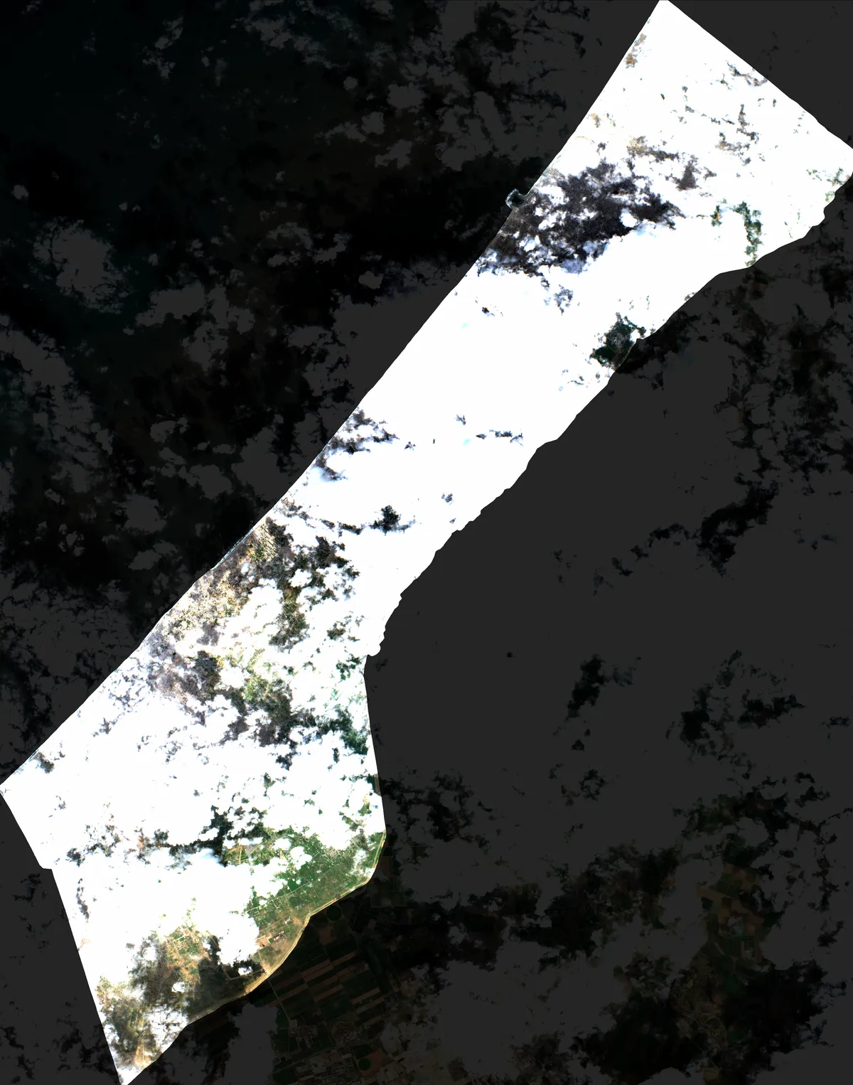
Coverage Analysis: 2026-01-14
Sentinel-2 Cloud Mask Overlay Visualization
⚠️ 98.2% Total Contamination
☁️ 85.4% Cloud Cover
🌑 12.9% Shadows
🛰️ S2C
📐 10m/Pixel
📖 Cite Me
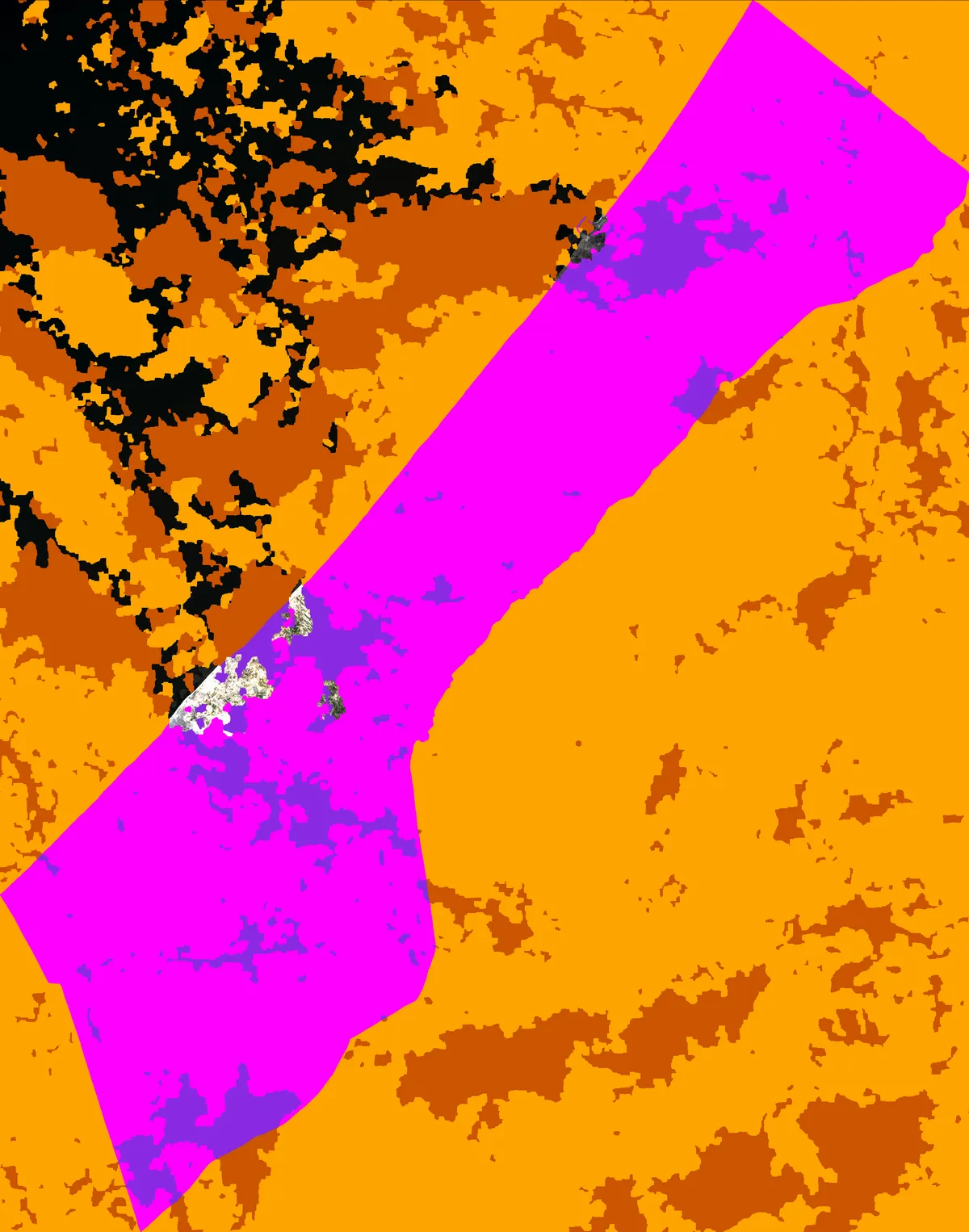
☁️ Cloud & Shadow Detection
Cloud and shadow masks are generated using OmniCloudMask, a deep learning ensemble trained on the CloudSEN12 dataset. The model processes three spectral bands (Red, Green, Near-Infrared) from Sentinel-2 imagery to classify pixels as clear, cloud, or shadow, then applies morphological post-processing to remove noise and smooth boundaries.
Coverage Analysis & Color Legend
- Total pixels: 13761176 (3289×4184 at 10m resolution)
- Total contaminated: 13519731 (98.2%)
- Clear areas within Gaza: 241445 (1.8%)
- Clouds within Gaza: 11747027 (85.4%)
- Shadows within Gaza: 1772703 (12.9%)
- Clouds outside Gaza
- Shadows outside Gaza
📚 OmniCloudMask Reference
Model
OmniCloudMask
Authors
Wright, N. J.; Duncan, J. M. A.; Callow, J. N.; Thompson, S. E.; George, R. J.
Publication
Remote Sensing of Environment, 322, 114694 (2025)
Repository
github.com/DPIRD-DMA/OmniCloudMask
License
MIT
🛰️ Product Information & Attribution
Product ID
S2C_MSIL2A_20260114T082311_N0511_R121_T36RXV_20260114T111810
Sensing Time
2026-01-14 08:23:11 UTC
Orbit
121
Tile ID
T36RXV
Processing Baseline
N051
Credit Line
Contains modified Copernicus Sentinel data 2026
Data Source
https://dataspace.copernicus.eu/
Modifications
Official L2A TCI raster cropped to Gaza Strip AOI with visualization overlays: hot magenta/neon purple cloud/shadow mask overlay.
×
Citation Formats
Chicago Style
European Commission Copernicus Programme. Sentinel-2 Level-2A satellite imagery. Contains modified Copernicus Sentinel data 2026. Processed by Sentinel Bird. Accessed January 14, 2026. https://dataspace.copernicus.eu/
Wright, Nicholas, John M.A. Duncan, J. Nik Callow, Sally E. Thompson, and Richard George. "Training Sensor-Agnostic Deep Learning Models for Remote Sensing: Achieving State-of-the-Art Cloud and Cloud Shadow Identification with OmniCloudMask." Remote Sensing of Environment 322 (2025): 114694. https://doi.org/10.1016/j.rse.2025.114694
Sentinel Bird. "Cloud Coverage Analysis for 2026-01-14." Sentinel Bird Gaza Satellite Analysis. Accessed January 14, 2026. https://sentinelbird.com/dates/2026-01-14/cloud_masks/.
MLA Style
European Commission Copernicus Programme. Sentinel-2 Level-2A satellite imagery. Contains modified Copernicus Sentinel data 2026. Processed by Sentinel Bird. Copernicus Data Space Ecosystem, https://dataspace.copernicus.eu/. Accessed 14 Jan. 2026.
Wright, Nicholas, et al. "Training Sensor-Agnostic Deep Learning Models for Remote Sensing: Achieving State-of-the-Art Cloud and Cloud Shadow Identification with OmniCloudMask." Remote Sensing of Environment, vol. 322, 2025, p. 114694, https://doi.org/10.1016/j.rse.2025.114694.
Sentinel Bird. "Cloud Coverage Analysis for 2026-01-14." Sentinel Bird Gaza Satellite Analysis, 2026, https://sentinelbird.com/dates/2026-01-14/cloud_masks/. Accessed 14 Jan. 2026.
Note: This visualization is a derived product. All three sources should be cited: Sentinel-2 data, OmniCloudMask methodology, and this visualization.